


Offline Waypoints Free
توضیحات Offline Waypoints Free
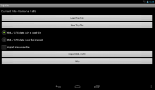
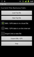
Offline Waypoints was designed from the ground up as an offline maps and way point solution. Plan your trip using the App, Google My Places, Google Earth, or any software that allows for KML or GPX exports.
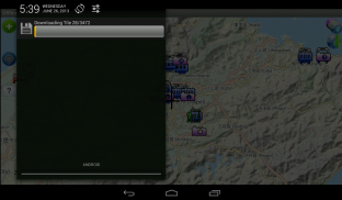
After you import or create your waypoints you can easily download all of the map information you need for your journey with just a couple of buttons when you have an internet connection. This will save you money (sometimes hundreds of dollars) by avoiding roaming fees when you leave your service area. It will save you from getting lost when you are going somewhere without service at all.
There is no need to spend time selecting areas for download. There is no storage space wasted by downloading unneeded map data.
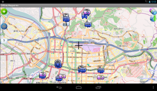
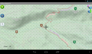
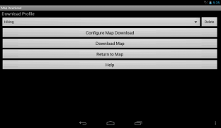
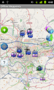
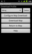
Offline Waypoints downloads the map area around the waypoints in your trip. Select how far away from each waypoint to download map data by your activity type (hiking, driving, city walking, etc) or using your own custom settings in an easy to use screen.
Here is a list of the features found in this app:
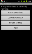
- Downloads map information as a background process so you can do other things with your device.
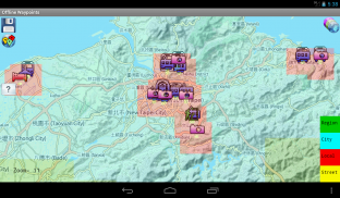
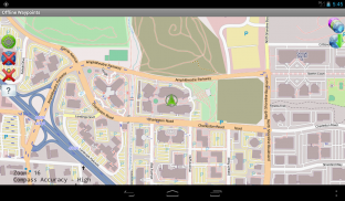
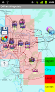
- Get a preview of where information will be downloaded before starting the tile download process.
- All way point information is stored offline on your device's external storage space. There is no need to be online once the map data is loaded.
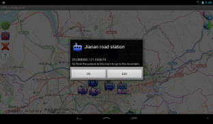
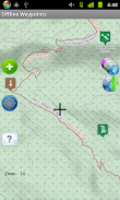
- Add new way points using the coordinates on the screen cursor, or your current GPS location.
- Way points are easily edited with on screen controls.
- Set how long for the app to retain GPS lock when the App is not in use for areas where it is hard to get a lock.
- Regain storage space by selecting previously downloaded map areas to delete.
Note on Google Maps:
Due to it's license for use, Google Maps tiles can not be stored locally. This app is meant as an offline map solution. However, if there is enough support I can add a Google Map Layer that is online use only.
</div> <div jsname="WJz9Hc" style="display:none">Offline Waypoints is ontworpen vanaf de grond opgebouwd als een offline kaarten en way point oplossing. Plan uw reis met behulp van de App, Google My Places, Google Earth, of enige software die het mogelijk maakt voor KML of GPX export.
Nadat u importeert of maak je waypoints kunt u gemakkelijk alle van de kaart informatie die u nodig hebt voor uw reis met slechts een paar knoppen te downloaden als je een internetverbinding hebt. Dit bespaart u geld (soms honderden euro's) door het vermijden van roaming-kosten wanneer u uw dienst gebied te verlaten. Het zal je redden van verdwalen als je ergens heen zonder service op alle.
Er is geen behoefte om tijd te besteden selecteren van gebieden om te downloaden. Er is geen opslagruimte verspild door het downloaden van onnodige kaartgegevens.
Offline Waypoints downloadt de kaart gebied rond de waypoints in uw reis. Selecteer hoe ver weg van elk waypoint om kaartgegevens te downloaden door uw type activiteit (wandelen, rijden, stad wandelen, etc) of met behulp van uw eigen aangepaste instellingen in een makkelijk te gebruiken scherm.
Hier is een lijst van de functies die in deze app:
- Downloads kaartinformatie als een achtergrond proces, zodat u kunt andere dingen doen met uw apparaat.
- Hier krijg je een voorproefje van waar de informatie zal worden gedownload voordat de tegel downloadproces.
- Alle way point informatie wordt opgeslagen offline op van uw apparaat externe opslagruimte. Er is geen behoefte om online te zijn zodra de kaartgegevens geladen.
- Voeg nieuwe manier punten met de coördinaten op de cursor, of uw huidige GPS-locatie.
- Way punten zijn gemakkelijk bewerkt met de controles het scherm.
- Stel in hoe lang de app te behouden GPS vergrendelen wanneer de App is niet in gebruik voor gebieden waar het moeilijk is om een slot te krijgen.
- Regain opslagruimte door het selecteren van eerder gedownloade kaart te wissen gebieden.
Opmerking op Google Maps:
Door zijn licentie voor gebruik, Google Maps tegels kan niet worden lokaal opgeslagen. Deze app is bedoeld als een offline kaart oplossing. Echter, als er voldoende steun kan ik een Google Map Layer die alleen online is te gebruiken toe te voegen.</div> <div class="show-more-end">
Offline Waypoints Free - نسخه 1.7.2
(29-06-2015)Offline Waypoints Free - اطلاعات APK
نسخه APK: 1.7.2حزمة: com.rjs3software.OfflineWaypoints.Freeآخرین نسخه Offline Waypoints Free
سایر نسخهها


اپلیکیشنها در دسته مشابه


شاید دوست داشته باشید...


